Coastal Data Exchange
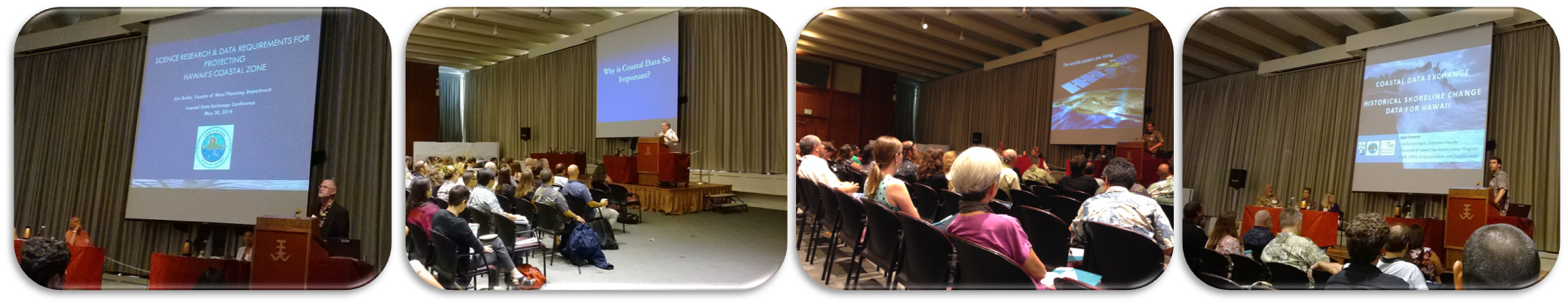
For the first time, coastal planners and data providers convened in a statewide forum to exchange knowledge, information, and best practices relating to decision making in the coastal zone. The 2014 Coastal Data Exchange brought together 130 people from more than 75 agencies and organizations.
The outcomes of the event included 1) a greater understanding of planning tools and practices, 2) discussion of data sharing capacity and platforms, 3) overview of law & policy aspects of using data in decision making, 4) improved access to needed data, and 5) a list of additional data needed to make coastal planning decisions.
To view presentations from the event, please click on the links in the agenda below.
Questions? Please contact the CZM Program office at 587-2846.
|
730 – 830 |
Registration |
|||||
| 830 – 900 | Keynote Address: Art Challacombe, City & County of Honolulu, Department of Planning & Permitting | |||||
|
900 – 1040 |
Planner Plenary |
|||||
|
Master Plans: Dean Watase, State Department of Transportation Harbors Division |
||||||
|
Conservation District Use Permits: Alex Roy, State DLNR Office of Conservation & Coastal Lands |
||||||
|
Shoreline Certification: Andy Bohlander, State DLNR Office of Conservation & Coastal Lands |
||||||
|
General Flood Control Plan: Darron Agawa, State DLNR Engineering Division |
||||||
|
Floodplain Management: Carter Romero, County of Hawaii Public Works Engineering Division |
||||||
|
Science Research & Data for Coastal Zone Protection: Jim Buika, County of Maui Planning Department |
||||||
|
Erosion-Based Setbacks: Tara Owens, UH Sea Grant/ County of Maui Planning Department |
||||||
|
Community Plans: Art Challacombe, City & County of Honolulu, Department of Planning & Permitting |
||||||
|
General Plans: Leanora Kaiaokamalie, County of Kauai Planning Department |
||||||
|
1040 – 1100 |
Break |
|||||
|
1100 – 1145 |
GIS Panel on Data Sharing: Maui County GIS, Hawaii County GIS, City & County of Honolulu GIS, Kauai County GIS, Hawaii State GIS Program, Hawaii Geographic Information Coordinating Council |
|||||
|
1145 – 1230 |
Law & Policy Panel on Data in Decision Making: Bryan Yee, Department of the Attorney General, and Douglas Codiga, UH Sea Grant |
|||||
|
1230 – 115 |
Lunch (Garden Level) |
|||||
|
115 – 230 |
Data Plenary |
|||||
|
Parcel Layers/ Tax Map Key: Royce Jones, Environmental Systems Research Institute, Inc. |
||||||
|
Historical Shoreline Change Data for Hawaii: Dr. Bradley Romine, UH Sea Grant and State DLNR |
||||||
|
USACE 2013 Topo/ Bathy LiDAR Survey of Hawaiian Islands: Jessica Podoski, US Army Corps of Engineers |
||||||
|
Mapping Sea Level Rise Inundation: Dr. Chip Fletcher, UH School of Ocean & Earth Science & Technology |
||||||
|
240 – 400 |
Concurrent Data Sessions |
|||||
|
Data for Today’s Coasts: Permitting Data |
FEMA Digital Flood Insurance Rate Maps |
|||||
|
Capturing Threats: Coastal Hazards Data |
Global Hazards Atlas |
|||||
|
Protecting Assets: Critical Facilities Data |
||||||
|
Data for Tomorrow: Sea Level Rise (SLR) Modeling |
||||||
|
400 – 500 |
PAU HANA Speed Data-ing! Get to know your data providers (Garden Level) |
|||||